Thursday, 24 November 2011
Harwich!
I saw that Harwich (or rather Dovercourt!) seems to have a new deli on the High Street. This is exciting news indeed :)
Sunday, 25 September 2011
Photos of a completed Crag Walk
(taken at Easter, 2011):
 |
| The Naze Tower |
 |
| The Crag Walk from the north end |
 |
| The slumped cliffs - lots of sands and gravels. Clay at the bottom |
 |
| the Rip Rap underneath the Crag Walk |

 |
| the view from above |
 |
| from the end of the Crag Walk (north). High water. |
 |
| I think the Crag Walk will stabilise the slumping therefore stabilise the cliffs |
Friday, 23 September 2011
some photos for Hadleigh...
I have taken some photos of the area where the proposed Tesco site would be and the surrounding area. As I said before, the new Tesco site is just behind the High Street, with the access through the allotments at the very end of the High Street by the river. As far as I can see the River Walk wouldn't be directly affected as it is on the other side of the river; however obviously pollution and litter could potentially influence the River Brett, which would in turn affect the River Walk.
Watch this space for any further development regarding the Tesco campaign.
Rachael
 |
| Hadleigh High Street - a threat under Tesco |
 |
| The old Brett Works site - Tesco owned |
 |
| the entrance to the works |
 |
| the old works |
 |
| the beginning of the River Walk |
 |
| evidence of people being against |
 |
| the River Brett from the opposite side |
 |
| The River Walk |
 |
| the countryside on the other side of the River Brett |
 |
| hanging baskets - community pride? |
Watch this space for any further development regarding the Tesco campaign.
Rachael
Monday, 12 September 2011
Hadleigh - to tesco or not to tesco...?!
We visited Hadleigh last week as I was confused with the arguments surrounding the proposed Tesco development site. The old Brett Works site apparently (according to a random resident we bumped in to and got chatting to) has been owned by Tesco for some years, and they have just let it go into disrepair and dereliction. Therefore it is not an aesthetically pleasing location!
Looking into local opinion on websites such as the local town website and facebook it is apparent that there is a strong division. What was most confusing was that the residents who are pro the development were describing the area as 'an eyesore' where the land needed to be cleared up whereas the people who were against the proposed development talked about how the Tesco would ruin such a beautiful River Walk and water meadows. This got me thinking; how could the area be beautiful and an eyesore all in one go? so, I decided to go and do a little bit of exploration myself.
It turns out that the River Walk isn't actually on the same side of the river as the proposed Tesco site after all. Obviously if the Tesco development does go ahead then they will have to play with the river system to reduce flooding such as placing in reservoirs and the such like. This will clearly have an influence on the drainage basin for miles around, and this in turn will effect the river walk, but Tesco aren't proposing to build on the River Walk - so that cleared that one up!!
For any extra information and plans etc then you can access the website: http://www.hands-off-hadleigh.co.uk/ this is obviously an anti Tesco campaign but there is a lot of information for you to gather and make a more rounded opinion.
Below is a list of issues from the Hands off Hadleigh website:
Safety issues with access on a bend on a bridge
Traffic congestion when almost every route into Hadleigh is effectively single lane
Increased noise levels and pollution from increased traffic drawn into the town, when by-pass built in mid 80's to avoid this
Vitality and viability of existing traders and small shops in the High Street that sell a fine selection of locally grown produce
Impact on natural environment and neighbouring allotments -
First application to build a supermarket (not Tesco) turned down in 1987 on environmental grounds, what has changed since then?
Concern about run off of excess water and flooding
Impact on surrounding historic conservation area (St Mary's, The Deanery, The Guildhall) that proposed store will impinge on
73% of the town voted against a supermarket on the Brett Work Site in Electoral Reform Society Referendum involving every household in Hadleigh
Hadleigh - should it have a Tesco? there's clearly an area that needs maintaining and generating but is building a large superstore the answer? certainly food for thought when considering Hadleigh as a successful traditional market town.Here's a useful video which weighs up the pros and cons quite nicely:
http://www.guardian.co.uk/artanddesign/video/2010/jun/10/outrage-revisited-hadleigh-tesco-architecture
Thursday, 8 September 2011
Hadleigh websites/ references
Here are some useful websites which will provide you with some useful information surrounding Hadleigh.
The Hadleigh Society: http://www.hadsoc.org.uk/hadsoc/index.htm
Hands off Hadleigh: http://www.hands-off-hadleigh.co.uk/
Tesco application: http://www.eadt.co.uk/news/hadleigh_tesco_store_application_is_refused_1_954038
Action for Market Towns: http://towns.org.uk/
Creating the Greenest County: http://www.greensuffolk.org/
Hadleigh Community: http://www.hadleighpeople.co.uk/home
Transition Towns UK: http://www.transitionnetwork.org/ http://www.transitionnetwork.org/
Community Energy Toolkit: http://www.neweconomics.org/publications/shared-energy-toolkit
Wednesday, 7 September 2011
clone or home?
We often visit our local town of Hadleigh. The normal focus is to decide whether Hadleigh is a successful 'home town'; a good traditional high street with lots of independent shops and fewer chain (or clone) shops. We are all quite fond of Hadleigh; it has a certain quirkiness about it which makes it feel quintessentially English and everyone is very friendly. However, as with all these things, there are circumstances which may threaten this independent and traditional community.
It is worth considering factors such as the ongoing proposal to build a Tesco supermarket on the banks of the River Brett behind the High Street. It is also worth considering that Hadleigh is a mere 8 miles from the out-of-town retail park at Copdock. Hadleigh is also only 10 miles from the large town of Ipswich, which has a service centre serving most of north, east and mid Suffolk. However, with these factors it is undeniable that Hadleigh is still a rural setting and obviously has all the pros and cons of being such.
Importantly Hadleigh is in the county of Suffolk (not the Essex one!) and is fairly empathetic to the local government initiative of 'creating the greenest county' (http://www.greensuffolk.org/). Many of you will be aware of the transition town movement (http://www.transitionnetwork.org/) and it's aims; Hadleigh did consider joining this network but in the end decided to go down the independent route with 'Greener Hadleigh'. Unfortunately I haven't been very successful in finding a specific web page for this cause :( however, I do know that they are very good at organising events to try and encourage the participation in local food purchasing and attempts to keep carbon footprints low.
The thing that we are particularly interested in is the production and purchasing of food products locally. Hadleigh has 2 butchers, a farm shop, a small co op, a local hardware store as well as many local hairdressers, tea shops, newsagents and so on. So, how can we see whether Hadleigh is a clone town, or a home town? The NEF (New Economics Foundation) have written a very simple, but effective, technique of establishing this (http://www.geographyteachingtoday.org.uk/images/text/FW_clone_survey.pdf). Try it on your home town to compare to Hadleigh!
Whatever 21st century developments threaten the traditional high street it is lovely to see that whichever day of the week you visit Hadleigh there is always lots going on. It is without a doubt a high street that is supported by the local community, and this is evident by the numbers entering the independent shops on a regular basis.
I shall add some more about this at a later date....
Rachael
Tuesday, 30 August 2011
The Crag Walk
Lots of exciting things have been happening at Walton on the Naze this year. We found ourselves unable to go onto the unmanaged section of beach last autumn, which meant a sudden u-turn in what we were able to measure down there! However, for us Geographers to be able to witness such 'Geography in Action' was extremely exciting :)
So... why couldn't we get on the beach? There was a new piece of management being built!
So, we have watched this happen over the year (it wasn't entirely finished last time I was down there so there might be more to come).
Again, a photographic record gives you a much better idea than me rambling on.... :P


From what I can work out the Crag Walk is going to act as an anchor to the base of the cliff. It has been built parallel to the cliff, with about a 10m section of beach still behind it. I think that as the cliff slumps it will be stabilised by the Crag Walk, thus meaning that the cliff shouldn't slump much further. This will then (hopefully) save the Naze Tower from going over (that's the aim anyway!).I still haven't uploaded my latest photos but when I do I shall add them on here.
Rachael
So... why couldn't we get on the beach? There was a new piece of management being built!
So, we have watched this happen over the year (it wasn't entirely finished last time I was down there so there might be more to come).
Again, a photographic record gives you a much better idea than me rambling on.... :P
 |
| the unmanaged beach before |
 |
| the sea attacking the base of the cliffs |
 |
| cliff rotational slumping |
 |
| the original management - nothing! |

 |
| the wave cut platform of London Clay |
 |
| starting work on the Crag Walk - |
 |
| new Rip Rap |
 |
| extending the end of the sea wall |
 |
| work in progress |
 |
| from on top of the cliff |
 |
| placing the Rip Rap strategically |

 |
| erosion has always been an issue |
From what I can work out the Crag Walk is going to act as an anchor to the base of the cliff. It has been built parallel to the cliff, with about a 10m section of beach still behind it. I think that as the cliff slumps it will be stabilised by the Crag Walk, thus meaning that the cliff shouldn't slump much further. This will then (hopefully) save the Naze Tower from going over (that's the aim anyway!).I still haven't uploaded my latest photos but when I do I shall add them on here.
Rachael
Saturday, 13 August 2011
'Happisburgh' useful references...
There's a lot of great stuff on the internet, so I have created a reference list (of things that I found, there might be more!)
Happisburgh Village website: http://www.happisburgh.org/
Coastal Concern Action Group website: http://www.happisburgh.org.uk/
there's loads of really good stuff on here - especially relating to how the community are responding to coastal erosion problems.
http://www.happisburgh.org.uk/campaign/history a useful page of this website!
The Pathfinder project are the people with the money!
this website gives lots of really useful information regarding what projects are happening in the local area.
there's also some very good photos on this page, as well as some hints regarding the processes influencing the speed of erosion.
An excellent website with some suberb images and annotations from a fellow Geographer:
some newspaper articles about the people effected by the crumbling cliffs:
and so the residents are attempting to do something about this themselves:
other useful resources:
some video links:
http://www.youtube.com/watch?v=fmeKnHWpZTA In fact there’s loads on YouTube! Just type in 'Happisburgh'
useful aerial photos:
happy internet hunting - hopefully this is a good start for you :)
Rachael
to protect or not protect?
This week I travelled to North Norfolk (technically – although it’s more like East Norfolk!) to visit Happisburgh on a reci for a potential fieldwork site. The students are looking into whether it is worth protecting a certain stretch of coastline, and Happisburgh is their chosen focus. Well, some may say that it’s too late to be discussing such a thing as the cliffs are retreating at such an alarming rate! Some attempt has been made to stop the slumping and undercutting, but mostly this seems to have just slowed processes but not stopped them.
here is a photographic record of my day!
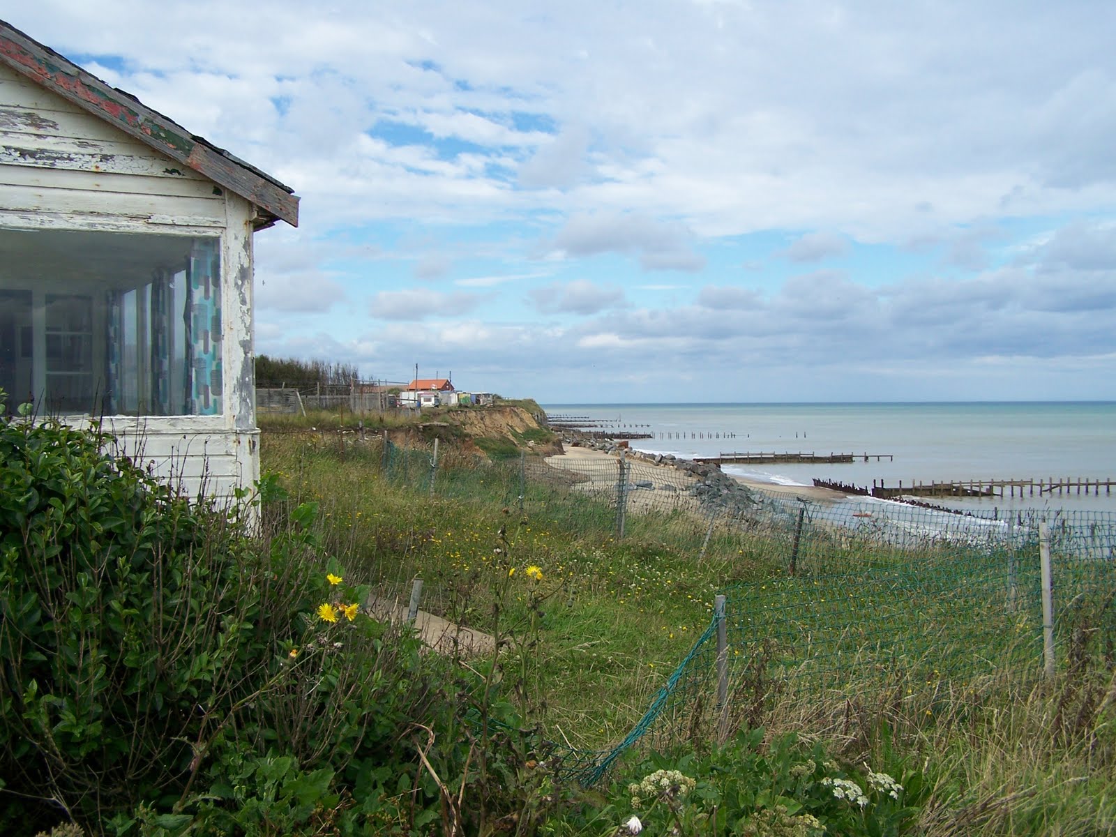
 |
| the lifeboat ramp - not much use now! |
 |
| south along the beach - is management working? |
 |
| tourist honeypot? |
 |
| debris falling off the cliff! |
 |
| the lifeboat ramp |
 |
| rip rap revetment - slowing the undercutting? |
 |
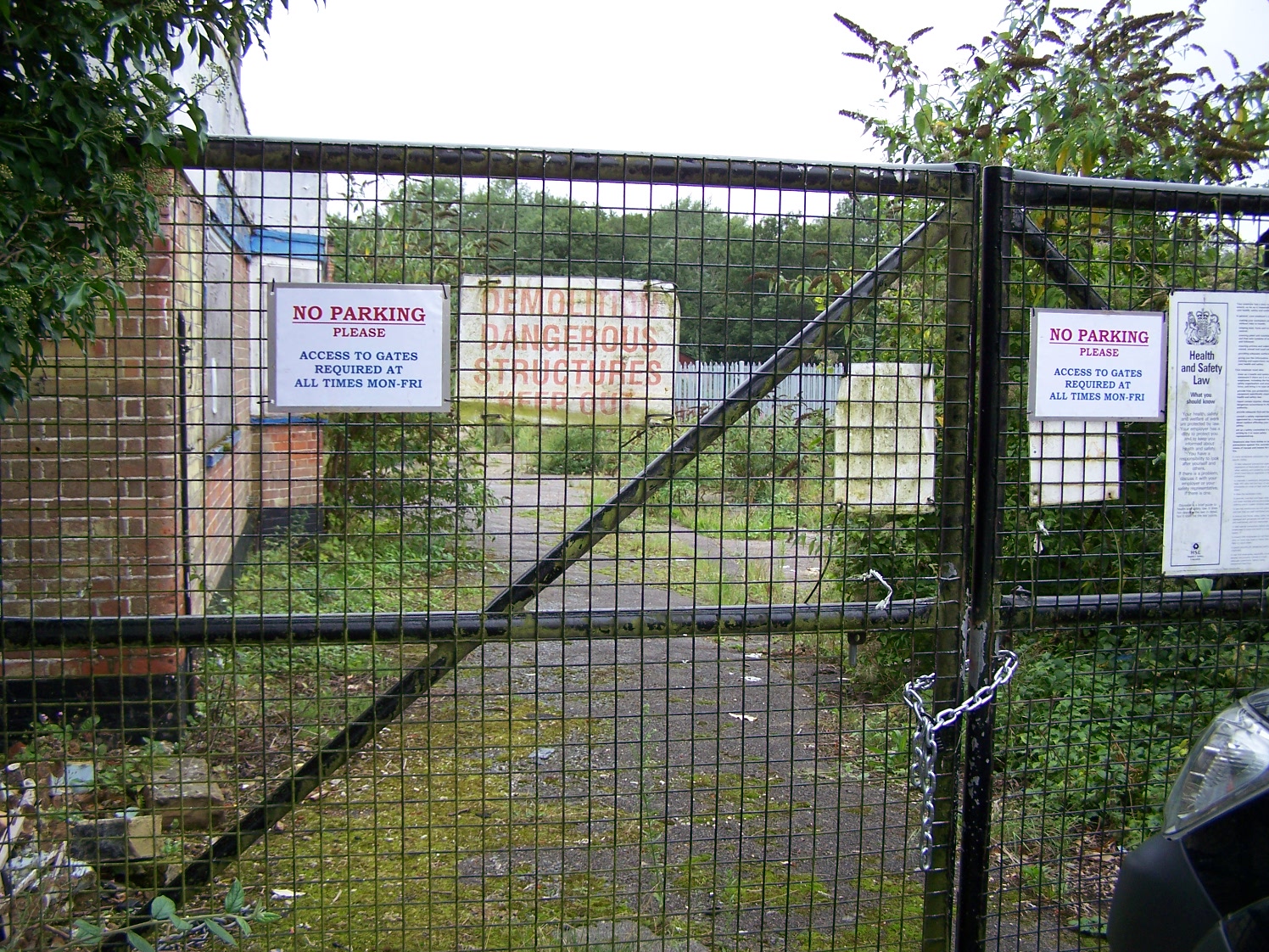
| Aesthetics & health and safety! |
 |
| residents have moved out! |
 |
| very close to the edge! |
 |
| ...left behind... |
 |
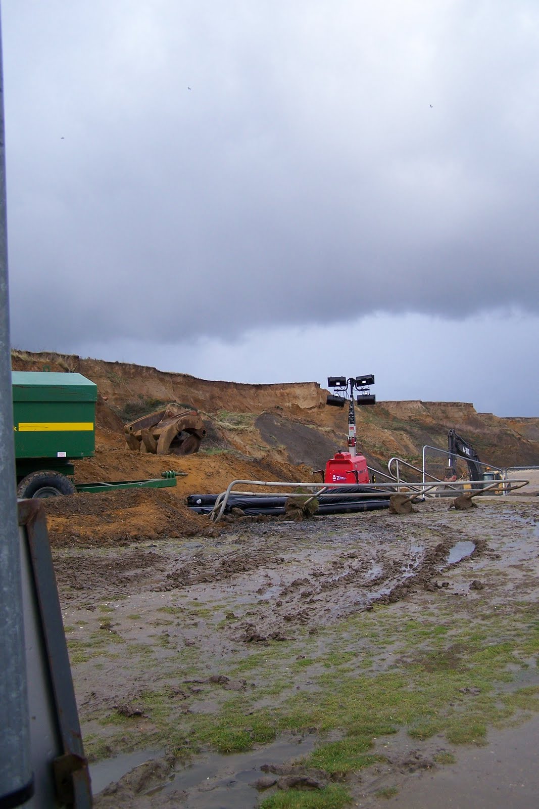
| where the new ramp will be (behind) |
 |
| from the unmanaged section |
 |
| the mess that's been left is being cleared this summer |
 |
| Beach Road has been closed |
 |
| the bottom of the lifeboat ramp |
 |
| looking north |
 |
| impact on business? all closed. |
 |
| empty house |
 |
| new carpark/ toilets and ramp |
 |
| just 5 miles up the road! |

Subscribe to:
Comments (Atom)